Changer L'orientation du repère de carte de Google en fonction de la direction du chemin
j'aimerais savoir s'il est possible de changer l'orientation du marqueur en fonction du chemin tracé sur la carte. Voici un exemple:
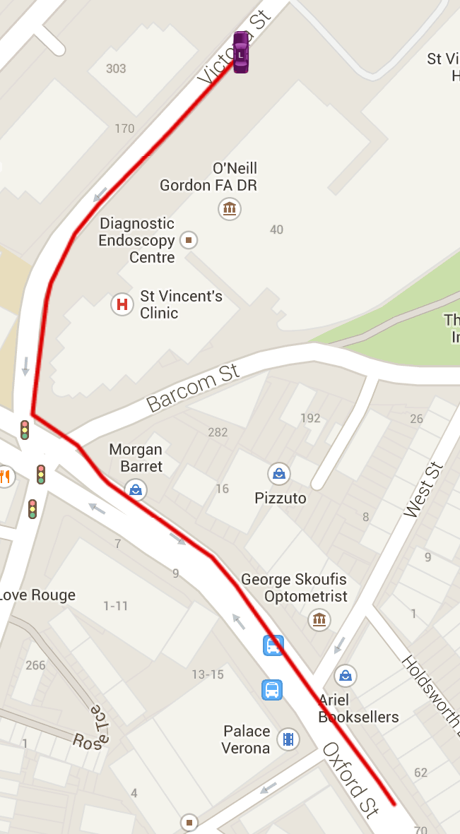
j'utilise DirectionsService pour dessiner le chemin et j'ai un nombre aléatoire de points. Parfois, un seul, parfois 10 points. J'Ajoute les marqueurs avant de tracer les chemins. Voici comment je dessine le chemin:
// Intialize the Path Array
var path = new google.maps.MVCArray();

// Intialise the Direction Service
var service = new google.maps.DirectionsService();

// Set the Path Stroke Color
var poly = new google.maps.Polyline({ map: gmap, strokeColor: '#dd0000' }); // #4986E7

// Draw the path for this vehicle
for (var i = 0; i < pathPoints.length; i++) {
    if ((i + 1) < pathPoints.length) {
        var src = pathPoints[i];
        var des = pathPoints[i + 1];
        path.push(src);
        poly.setPath(path);
        service.route({
            origin: src,
            destination: des,
            travelMode: google.maps.DirectionsTravelMode.DRIVING
        }, function (result, status) {
            if (status == google.maps.DirectionsStatus.OK) {
                for (var i = 0, len = result.routes[0].overview_path.length; i < len; i++){
                    path.push(result.routes[0].overview_path[i]);
                }
            }
        });
    }
}
Est-il possible de faire cela?
Cheers, Maxime
1 réponses
une option est de traduire votre icône en SVG puis d'utiliser le symbole rotation propriété de l'aligner avec la route (vous pouvez faire la même chose avec une image PNG en soit de fabriquer un grand nombre de copies de l'icône rotation par un degré ou deux, ou par une icône personnalisée qui permet de faire pivoter l'icône PNG arbitrairement)
marker.setPosition(p);
var heading = google.maps.geometry.spherical.computeHeading(lastPosn,p);
icon.rotation = heading;
marker.setIcon(icon);
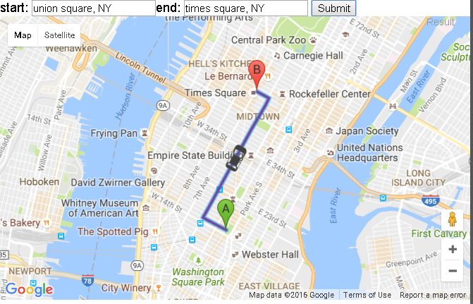
code extrait de:
var map;
var directionDisplay;
var directionsService;
var stepDisplay;
var markerArray = [];
var position;
var marker = null;
var polyline = null;
var poly2 = null;
var speed = 0.000005,
  wait = 1;
var infowindow = null;
var timerHandle = null;

function createMarker(latlng, label, html) {
  var contentString = '<b>' + label + '</b><br>' + html;
  var marker = new google.maps.Marker({
    position: latlng,
    map: map,
    title: label,
    zIndex: Math.round(latlng.lat() * -100000) << 5
  });
  marker.myname = label;
  google.maps.event.addListener(marker, 'click', function() {
    infowindow.setContent(contentString);
    infowindow.open(map, marker);
  });
  return marker;
}

function initialize() {
  infowindow = new google.maps.InfoWindow({
    size: new google.maps.Size(150, 50)
  });
  // Instantiate a directions service.
  directionsService = new google.maps.DirectionsService();

  // Create a map and center it on Manhattan.
  var myOptions = {
    zoom: 13,
    mapTypeId: google.maps.MapTypeId.ROADMAP
  };
  map = new google.maps.Map(document.getElementById("map_canvas"), myOptions);

  address = 'new york';
  geocoder = new google.maps.Geocoder();
  geocoder.geocode({
    'address': address
  }, function(results, status) {
    map.setCenter(results[0].geometry.location);
  });

  // Create a renderer for directions and bind it to the map.
  var rendererOptions = {
    map: map
  };
  directionsDisplay = new google.maps.DirectionsRenderer(rendererOptions);

  // Instantiate an info window to hold step text.
  stepDisplay = new google.maps.InfoWindow();

  polyline = new google.maps.Polyline({
    path: [],
    strokeColor: '#FF0000',
    strokeWeight: 3
  });
  poly2 = new google.maps.Polyline({
    path: [],
    strokeColor: '#FF0000',
    strokeWeight: 3
  });
}

var steps = [];

function calcRoute() {

  if (timerHandle) {
    clearTimeout(timerHandle);
  }
  if (marker) {
    marker.setMap(null);
  }
  polyline.setMap(null);
  poly2.setMap(null);
  directionsDisplay.setMap(null);
  polyline = new google.maps.Polyline({
    path: [],
    strokeColor: '#FF0000',
    strokeWeight: 3
  });
  poly2 = new google.maps.Polyline({
    path: [],
    strokeColor: '#FF0000',
    strokeWeight: 3
  });
  // Create a renderer for directions and bind it to the map.
  var rendererOptions = {
    map: map
  };
  directionsDisplay = new google.maps.DirectionsRenderer(rendererOptions);

  var start = document.getElementById("start").value;
  var end = document.getElementById("end").value;
  var travelMode = google.maps.DirectionsTravelMode.DRIVING;

  var request = {
    origin: start,
    destination: end,
    travelMode: travelMode
  };

  // Route the directions and pass the response to a
  // function to create markers for each step.
  directionsService.route(request, function(response, status) {
    if (status == google.maps.DirectionsStatus.OK) {
      directionsDisplay.setDirections(response);

      var bounds = new google.maps.LatLngBounds();
      var route = response.routes[0];
      startLocation = new Object();
      endLocation = new Object();

      // For each route, display summary information.
      var path = response.routes[0].overview_path;
      var legs = response.routes[0].legs;
      for (i = 0; i < legs.length; i++) {
        if (i === 0) {
          startLocation.latlng = legs[i].start_location;
          startLocation.address = legs[i].start_address;
          //   marker = createMarker(legs[i].start_location, "start", legs[i].start_address, "green");
        }
        endLocation.latlng = legs[i].end_location;
        endLocation.address = legs[i].end_address;
        var steps = legs[i].steps;
        for (j = 0; j < steps.length; j++) {
          var nextSegment = steps[j].path;
          for (k = 0; k < nextSegment.length; k++) {
            polyline.getPath().push(nextSegment[k]);
            bounds.extend(nextSegment[k]);
          }
        }
      }
      polyline.setMap(map);
      map.fitBounds(bounds);
      map.setZoom(18);
      startAnimation();
    }
  });
}


var step = 50; // 5; // metres
var tick = 100; // milliseconds
var eol;
var k = 0;
var stepnum = 0;
var speed = "";
var lastVertex = 1;

//=============== animation functions ======================
function updatePoly(d) {
  // Spawn a new polyline every 20 vertices, because updating a 100-vertex poly is too slow
  if (poly2.getPath().getLength() > 20) {
    poly2 = new google.maps.Polyline([polyline.getPath().getAt(lastVertex - 1)]);
    // map.addOverlay(poly2)
  }

  if (polyline.GetIndexAtDistance(d) < lastVertex + 2) {
    if (poly2.getPath().getLength() > 1) {
      poly2.getPath().removeAt(poly2.getPath().getLength() - 1);
    }
    poly2.getPath().insertAt(poly2.getPath().getLength(), polyline.GetPointAtDistance(d));
  } else {
    poly2.getPath().insertAt(poly2.getPath().getLength(), endLocation.latlng);
  }
}

function animate(d) {
  if (d > eol) {
    map.panTo(endLocation.latlng);
    marker.setPosition(endLocation.latlng);
    return;
  }
  var p = polyline.GetPointAtDistance(d);
  map.panTo(p);
  var lastPosn = marker.getPosition();
  marker.setPosition(p);
  var heading = google.maps.geometry.spherical.computeHeading(lastPosn, p);
  icon.rotation = heading;
  marker.setIcon(icon);
  updatePoly(d);
  timerHandle = setTimeout("animate(" + (d + step) + ")", tick);
}

function startAnimation() {
  eol = polyline.Distance();
  map.setCenter(polyline.getPath().getAt(0));
  marker = new google.maps.Marker({
    position: polyline.getPath().getAt(0),
    map: map,
    icon: icon
  });

  poly2 = new google.maps.Polyline({
    path: [polyline.getPath().getAt(0)],
    strokeColor: "#0000FF",
    strokeWeight: 10
  });
  // map.addOverlay(poly2);
  setTimeout("animate(50)", 2000); // Allow time for the initial map display
}
google.maps.event.addDomListener(window, 'load', initialize);

//=============== ~animation funcitons =====================

var car = "M17.402,0H5.643C2.526,0,0,3.467,0,6.584v34.804c0,3.116,2.526,5.644,5.643,5.644h11.759c3.116,0,5.644-2.527,5.644-5.644 V6.584C23.044,3.467,20.518,0,17.402,0z M22.057,14.188v11.665l-2.729,0.351v-4.806L22.057,14.188z M20.625,10.773 c-1.016,3.9-2.219,8.51-2.219,8.51H4.638l-2.222-8.51C2.417,10.773,11.3,7.755,20.625,10.773z M3.748,21.713v4.492l-2.73-0.349 V14.502L3.748,21.713z M1.018,37.938V27.579l2.73,0.343v8.196L1.018,37.938z M2.575,40.882l2.218-3.336h13.771l2.219,3.336H2.575z M19.328,35.805v-7.872l2.729-0.355v10.048L19.328,35.805z";
var icon = {
  path: car,
  scale: .7,
  strokeColor: 'white',
  strokeWeight: .10,
  fillOpacity: 1,
  fillColor: '#404040',
  offset: '5%',
  // rotation: parseInt(heading[i]),
  anchor: new google.maps.Point(10, 25) // orig 10,50 back of car, 10,0 front of car, 10,25 center of car
};

/*********************************************************************\
*                                                                     *
* epolys.js                                          by Mike Williams *
* updated to API v3                                  by Larry Ross    *
*                                                                     *
* A Google Maps API Extension                                         *
*                                                                     *
* Adds various Methods to google.maps.Polygon and google.maps.Polyline *
*                                                                     *
* .Contains(latlng) returns true is the poly contains the specified   *
*                   GLatLng                                           *
*                                                                     *
* .Area()           returns the approximate area of a poly that is    *
*                   not self-intersecting                             *
*                                                                     *
* .Distance()       returns the length of the poly path               *
*                                                                     *
* .Bounds()         returns a GLatLngBounds that bounds the poly      *
*                                                                     *
* .GetPointAtDistance() returns a GLatLng at the specified distance   *
*                   along the path.                                   *
*                   The distance is specified in metres               *
*                   Reurns null if the path is shorter than that      *
*                                                                     *
* .GetPointsAtDistance() returns an array of GLatLngs at the          *
*                   specified interval along the path.                *
*                   The distance is specified in metres               *
*                                                                     *
* .GetIndexAtDistance() returns the vertex number at the specified    *
*                   distance along the path.                          *
*                   The distance is specified in metres               *
*                   Returns null if the path is shorter than that      *
*                                                                     *
* .Bearing(v1?,v2?) returns the bearing between two vertices          *
*                   if v1 is null, returns bearing from first to last *
*                   if v2 is null, returns bearing from v1 to next    *
*                                                                     *
*                                                                     *
***********************************************************************
*                                                                     *
*   This Javascript is provided by Mike Williams                      *
*   Blackpool Community Church Javascript Team                        *
*   http://www.blackpoolchurch.org/                                   *
*   http://econym.org.uk/gmap/                                        *
*                                                                     *
*   This work is licenced under a Creative Commons Licence            *
*   http://creativecommons.org/licenses/by/2.0/uk/                    *
*                                                                     *
***********************************************************************
*                                                                     *
* Version 1.1       6-Jun-2007                                        *
* Version 1.2       1-Jul-2007 - fix: Bounds was omitting vertex zero *
*                                add: Bearing                         *
* Version 1.3       28-Nov-2008  add: GetPointsAtDistance()           *
* Version 1.4       12-Jan-2009  fix: GetPointsAtDistance()           *
* Version 3.0       11-Aug-2010  update to v3                         *
*                                                                     *
\*********************************************************************/

// === first support methods that don't (yet) exist in v3
google.maps.LatLng.prototype.distanceFrom = function(newLatLng) {
  var EarthRadiusMeters = 6378137.0; // meters
  var lat1 = this.lat();
  var lon1 = this.lng();
  var lat2 = newLatLng.lat();
  var lon2 = newLatLng.lng();
  var dLat = (lat2 - lat1) * Math.PI / 180;
  var dLon = (lon2 - lon1) * Math.PI / 180;
  var a = Math.sin(dLat / 2) * Math.sin(dLat / 2) + Math.cos(lat1 * Math.PI / 180) * Math.cos(lat2 * Math.PI / 180) * Math.sin(dLon / 2) * Math.sin(dLon / 2);
  var c = 2 * Math.atan2(Math.sqrt(a), Math.sqrt(1 - a));
  var d = EarthRadiusMeters * c;
  return d;
}

google.maps.LatLng.prototype.latRadians = function() {
  return this.lat() * Math.PI / 180;
}

google.maps.LatLng.prototype.lngRadians = function() {
  return this.lng() * Math.PI / 180;
}

// === A method which returns the length of a path in metres ===
google.maps.Polygon.prototype.Distance = function() {
  var dist = 0;
  for (var i = 1; i < this.getPath().getLength(); i++) {
    dist += this.getPath().getAt(i).distanceFrom(this.getPath().getAt(i - 1));
  }
  return dist;
}

// === A method which returns a GLatLng of a point a given distance along the path ===
// === Returns null if the path is shorter than the specified distance ===
google.maps.Polygon.prototype.GetPointAtDistance = function(metres) {
  // some awkward special cases
  if (metres == 0) return this.getPath().getAt(0);
  if (metres < 0) return null;
  if (this.getPath().getLength() < 2) return null;
  var dist = 0;
  var olddist = 0;
  for (var i = 1;
    (i < this.getPath().getLength() && dist < metres); i++) {
    olddist = dist;
    dist += this.getPath().getAt(i).distanceFrom(this.getPath().getAt(i - 1));
  }
  if (dist < metres) {
    return null;
  }
  var p1 = this.getPath().getAt(i - 2);
  var p2 = this.getPath().getAt(i - 1);
  var m = (metres - olddist) / (dist - olddist);
  return new google.maps.LatLng(p1.lat() + (p2.lat() - p1.lat()) * m, p1.lng() + (p2.lng() - p1.lng()) * m);
}

// === A method which returns an array of GLatLngs of points a given interval along the path ===
google.maps.Polygon.prototype.GetPointsAtDistance = function(metres) {
  var next = metres;
  var points = [];
  // some awkward special cases
  if (metres <= 0) return points;
  var dist = 0;
  var olddist = 0;
  for (var i = 1;
    (i < this.getPath().getLength()); i++) {
    olddist = dist;
    dist += this.getPath().getAt(i).distanceFrom(this.getPath().getAt(i - 1));
    while (dist > next) {
      var p1 = this.getPath().getAt(i - 1);
      var p2 = this.getPath().getAt(i);
      var m = (next - olddist) / (dist - olddist);
      points.push(new google.maps.LatLng(p1.lat() + (p2.lat() - p1.lat()) * m, p1.lng() + (p2.lng() - p1.lng()) * m));
      next += metres;
    }
  }
  return points;
}

// === A method which returns the Vertex number at a given distance along the path ===
// === Returns null if the path is shorter than the specified distance ===
google.maps.Polygon.prototype.GetIndexAtDistance = function(metres) {
    // some awkward special cases
    if (metres == 0) return this.getPath().getAt(0);
    if (metres < 0) return null;
    var dist = 0;
    var olddist = 0;
    for (var i = 1;
      (i < this.getPath().getLength() && dist < metres); i++) {
      olddist = dist;
      dist += this.getPath().getAt(i).distanceFrom(this.getPath().getAt(i - 1));
    }
    if (dist < metres) {
      return null;
    }
    return i;
  }
  // === Copy all the above functions to GPolyline ===
google.maps.Polyline.prototype.Distance = google.maps.Polygon.prototype.Distance;
google.maps.Polyline.prototype.GetPointAtDistance = google.maps.Polygon.prototype.GetPointAtDistance;
google.maps.Polyline.prototype.GetPointsAtDistance = google.maps.Polygon.prototype.GetPointsAtDistance;
google.maps.Polyline.prototype.GetIndexAtDistance = google.maps.Polygon.prototype.GetIndexAtDistance;
html {
height: 100%;
}
body {
height: 100%;
margin: 0px;
font-family: Helvetica, Arial;
}<script src="https://maps.googleapis.com/maps/api/js?libraries=geometry"></script>
<div id="tools">start:
<input type="text" name="start" id="start" value="union square, NY" />end:
<input type="text" name="end" id="end" value="times square, NY" />
<input type="submit" onclick="calcRoute();" />
</div>
<div id="map_canvas" style="width:100%;height:90%;"></div>